Drainage enforcement using existing
single-line hydrography.
Originally
intended to guide flow paths through areas of low relief where channel courses were not resolved or were ambiguous on DEM.
Subsequently
used to force flow to follow existing hydrography (can lead to inconsistent channel gradients).
Strategy:
•On a duplicate DEM, incise a “swale”
of specified width and depth where
drainage is to be enforced.
of specified width and depth where
drainage is to be enforced.
•Depth and width of swale are user
specified;
provides for more or less enforcement.
provides for more or less enforcement.
•Swale excavation can be limited to a
user-specified range of channel gradients.
This prevents drainage enforcement on steep slopes, where errors in location create anomalous channel gradients.
•Flow directions are calculated using the
modified DEM.
•All subsequent
calculations are made on the original DEM.
•Channel initiation may be allowed along
enforced channels,
even if all criteria are not met.
even if all criteria are not met.
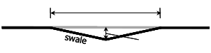
width
depth
Original topography