3.5.4.1. Calculate Fish Distribution
Calculate/Modify Fish Distribution
Tool Description:
The purpose of this tool is to identify the portion of the stream network that is accessible to fish. This is done by identifying several types of physical barriers to fish passage and delineating the portion of the network below these barriers. Barrier types that can be identified area 1) gradient barriers, 2) waterfall barriers, and 3) non-vertical obstacles (cascades). These types of barriers can be identified using different length scales.
Gradient [GRADIENT] is calculated using a moving window over the node network. The window length can either be fixed or variable (determined by drainage area). For example, one length scale can be specified above an area threshold and another length scale can be specified below an area threshold. This could be useful when identifying fish barriers that have a channel gradient threshold that is applied over different length scales depending on location in a basin. Consider fish passage barriers (for example, an 8% gradient for salmonids). A short section of 8% channel gradient (say 10 m) might be surmountable for fish passage. However, if the 8% gradient extended for a couple of hundred meters, that might pose a fish barrier. Maximum downstream gradient is calculated for each reach and stored as the [MAX_GRAD_D] attribute.
Waterfalls [DROP] and non-vertical obstacles [NVO] are defined over shorter windows than gradient. Waterfalls are determined by relief over a specified window, while non-vertical obstacles are determined as steep sections that exceed a specified gradient over a specified window. Maximum downstream waterfall and NVO heights are calculated for each reach and stored as the [DROPMAX] and [NVOMAX] attributes.
Maximum downstream values for any or all of the three parameters can be set as thresholds for fish barriers.
The portion of the network that does not exceed these thresholds will be defined as fish-bearing for the user-specified fish type. This will be set to the current fish distribution [FISH] = 1 and stored for reference as a separate attribute, e.g. [FISH_ANAD] = 1.
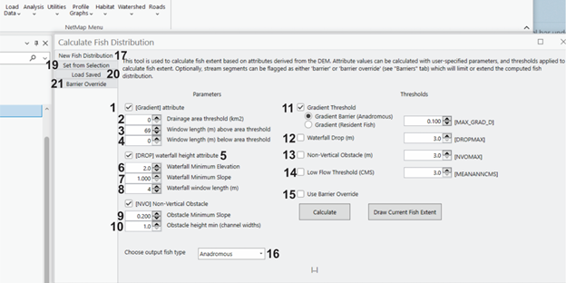
Figure 1. (1) Channel gradients can be calculated over any length scale. (2) An area threshold can be specified and then separate length scales (windows) can be indicated for above and below the area threshold (3, 4). (5) Waterfall fish barriers can be identified by indicating a minimum elevation drop over a length scale determined by specifying a minimum slope (6, 7). (8) When identifying waterfalls, a length window must be selected. Non-vertical obstacles (steep cascades for example) can be added as a barrier to fish migration. (9) and (10) indicate parameters used to measure NVOs. Parameter thresholds are set using 11 - 14. (15) Barriers can be overridden (see 21). The type of fish distribution is selected (16) and itgets indicated on all of NetMap tools (e.g., resident or anadromous and by species available in the drop down list).
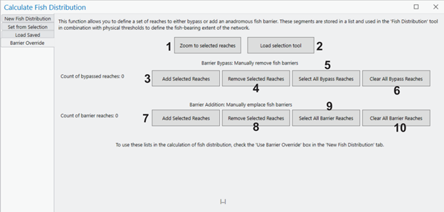
Figure 2. The "Barrier Override" tool allows users to either override or emplace barriers to fish passage. For example, one can assess habitat accessibility if a dam were to be removed (or emplaced). This tool creates and modifies two separate lists – one, “Barrier Bypass”, containing reaches to be bypassed (if they contain barriers) and another, “Barrier Addition”, to emplace barriers. Operations include:
1. Zoom to selected reaches
2. Load the selection tool
3. When reaches are selected, this will add them to the Barrier Bypass list
4. This will remove selected reaches from the Barrier Bypass list
5. This will select all reaches in the Barrier Bypass list
6. This will remove all reaches from the Barrier Bypass list
7. This will add selected reaches to the Barrier Addition list
8. This will remove selected reaches from the Barrier Addition list
9. This will select all reaches in the Barrier Addition list
10. This will remove all reaches from the Barrier Addition list
If the ‘Use Barrier Override’ box is checked, these lists will be incorporated and will affect the output as specified.
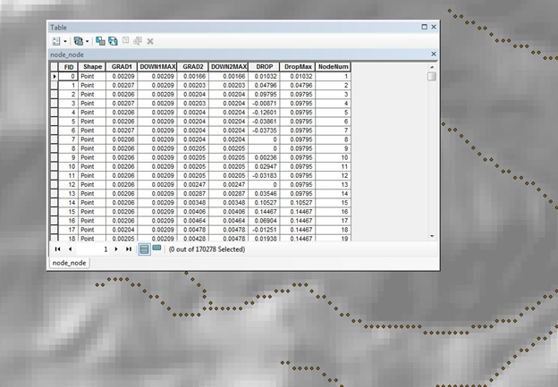
Figure 3. NetMap's node based stream layer with attributes.
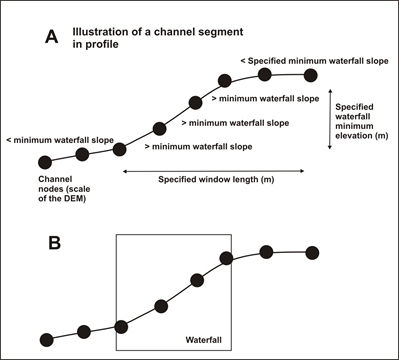
Figure 4. A waterfall is initiated when the node-to-node slope exceeds the WATERFALL MINIMUM SLOPE and the change in elevation over the upstream WINDOW LENGTH exceeds the WATERFALL MINIMUM ELEVATION. The waterfall flag continues until the node-to-node slope is less than the threshold and the elevation change over the upstream window is less than the elevation threshold and, if you included CHECK SLOPE, the maximum node-to-node slope over the upstream window is less than the slope threshold.