3.5.4.2. Floodplain Mapping
Floodplain Mapping/Of Channel Habitat Delineation
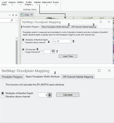
Tool Interface
Delineation of floodplains is a standard output in NetMap'v virtual watersheds. See background information below.
Figure 1. NetMap's ArcPro Floodplain tool interface. The three modeling outputs consist of floodplain polygons (1), a channel-reach floodplain width attribute (2), and floodplain topography as off-channel habitat (3). A user selects the number of bankfull depths for floodplain delineation (4); generally, bankfull depth categories of floodplain elevation less than three correspond to the active floodplain (5). Thus, it is good practice to select at least five or higher to document the transition from floodplains to terraces and alluvial fans.Floodplains can be mapped for a single channel (6-7) that requires specifying a specific channel ID (Figure 2). Or, floodplain for all channels in a watershed can be displayed (6-7).
When calculating and displaying the floodplain reach attribute (floodplain width located within the reach shapefile), a user must also specify a multiple of bankfull depth (elevation).
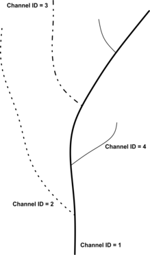
Figure 1. NetMap channel ID protocol. Starting at the mouth of the watershed, the channel segment extending to the headwaters with the largest drainage area is Channel ID = 1. The channel with the next largest drainage area is Channel ID = 2, and so on.
Model Background:
To characterize valley-floor surfaces in NetMap, DEM cells are classified according to elevation above the channel. Each cell within a specified search radius of a channel (a multiplier of bankfull widths) is associated to the closest channel cell, with distance to the channel weighted by intervening relief. Valley-floor DEM cells are associated with specific channel segments that are closest in Euclidean distance and have the fewest and smallest intervening high points. The elevation difference between each valley floor cell and the associated channel location is normalized by bankfull depth or by the absolute elevation above the channel. This procedure is repeated for every channel segment. For additional information on the use of NetMap’s floodplain mapping tool, see: http://www.hydrol-earth-syst-sci.net/15/2995/2011/ .
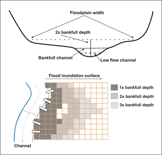
Figure 3. Floodplains are delineated in terms of elevation above the channel, either in multiples of bankfull depths or in absolute elevations. Bankfull depths offer the advantage of scaling the extent of floodplain mapping to the size of the channel. Geomorphologists generally consider 2x bankfull depths floodplain as the active floodplain surface.
The floodplain tool in NetMap allows the user to specify the height about the channel from which to estimate floodplain (or valley) width in units of bankfull depths or to using a fixed elevation above the channel (Figure 3). Floodplain or valley width can vary from the right to left sides of the channel. Since the DEM typically does not account for the bottom of a stream channel, a bankfull depth of one could be used to define floodplains, although the Rosgen stream classification system suggests a bankfull depth of two. It is recommended that a user make field observations (and use aerial photographs) to determine an appropriate height above the channel to measure floodplain width. The tool calculates floodplain width as a reach attribute and as a floodplain polygon. The polygon visually indicates that differences in floodplain width from the right to left sides of the channel.
Other tool options include selecting only one channel for the analysis. This option is designed to help clarify the floodplain extent along a single channel without the complicating and overlapping (floodplain) influences of intersecting tributaries (e.g., floodplains from mainstem channels and tributaries can interdigitate and overlap); this described in more detail below.
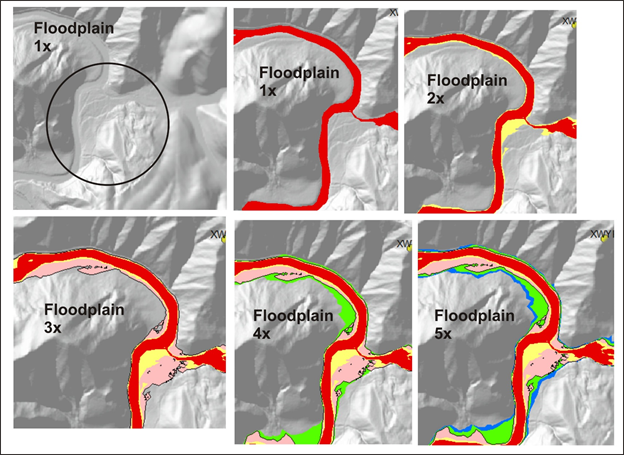
Figure 4. Floodplain at one multiple of bankfull depth (1x) generally identifies the active channel. Floodplain at two multiple of bankfull depth (2x) generally maps the lowest, most active floodplain, commonly thought to be inundated by the two-year flood (Dunne and Leopold 1978, Rosgen 1996). 3x floodplain is likely inundated by low frequency, high magnitude floods. 4x floodplain may represent an alluvial terrace or toeslopes of hillsides. Ditto for 5x and beyond.
Figure 5. NetMap's floodplain mapping tool, particularly using LiDAR, can be used to map the elevation diversity of floodplain surfaces (see floodplain mapping tools).
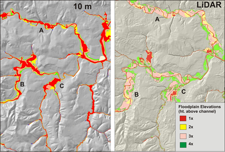
Figure 6. Although mapping floodplains using 10m DEMs (NetMap virtual watershed) is adequate (left panel), LiDAR (1-2m) provides considerably more detail and variability in floodplains.
Figure 7. An example of how NetMap’s floodplain mapping tool can be used to examine variable floodplain surfaces using a range of bankfull depths above the channel (e.g., 1 x bankfull depth, 2x, and 3x etc.). Shown above is the present day (diked and regulated) channel in a basin in Northern Spain with NetMap’s predicted floodplains shown at 1x, 2x, and 3x bankfull depths. NetMap was used to develop a catchment scale perspective for river restoration in Spain (http://www.hydrol-earth-syst-sci.net/15/2995/2011/ ).
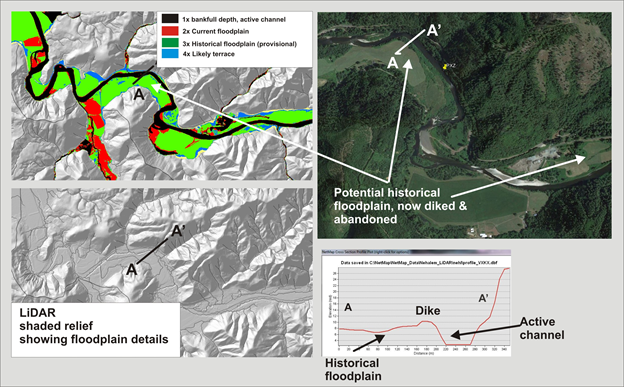
Figure 7. NetMap's floodplain mapping tool, particularly using high resolution LiDAR DEMs, can be used to identify the current floodplain and historical floodplains, now abandoned due to diking, stream cleaning, agriculture and channel incision; analysis in this figure uses 2.5 m LiDAR in the Nehalem watershed in northwestern coastal Oregon.
Figure 8. NetMap estimates floodplain width (individual left and right side or combined sides) and that channel segment data are stored in the reach attribute table in ArcGIS.
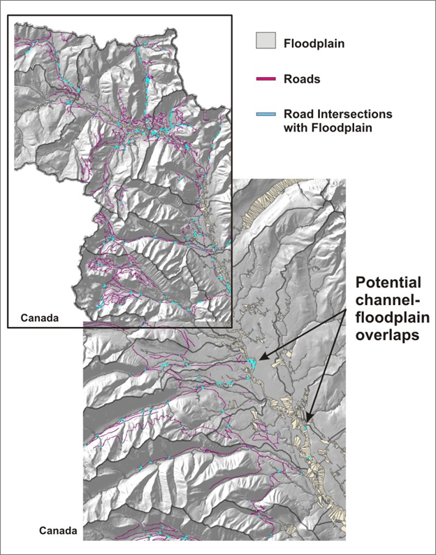
Figure 9. NetMap contains a tool for quickly identifying where roads may intersect floodplains. Refer to the NetMap’s Road Module. Field validation is recommended.
Technical Background
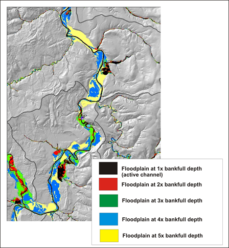
Floodplains typically lie at, or somewhat above, bankfull stage (Dunne and Leopold, 1978). In practice, zones of frequent inundation are defined by an elevation above the channel equivalent to two bankfull depths (Rosgen, 1996, Castro, 1977). To illustrate a wide range of flow inundation-valley topography relations in NetMap, multiple valley widths can be calculated, e.g., 2x, 3x, and 5x bankfull depths (Figure 4).
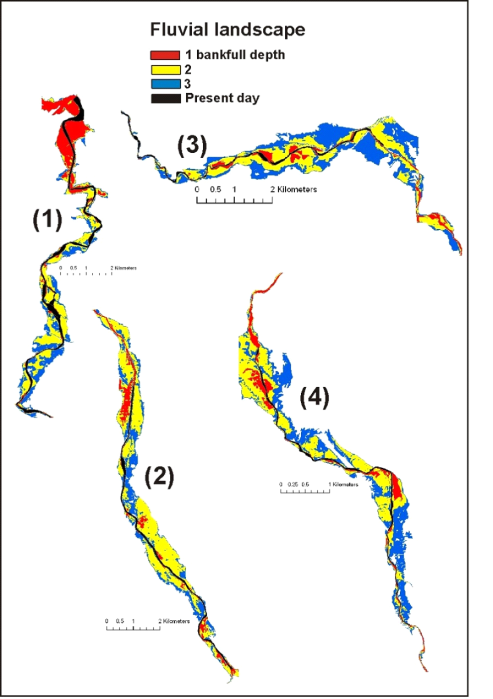
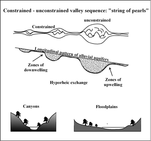
Geologic controls and major slope movements can create variations in floodplain (and valley width) and shape. Constrained (narrow) valleys typically lack sediment storage while unconstrained (wide) valley segments act as storage reservoirs of alluvial sediment, often creating wide, more complex floodplains within the fluvial landscape (Grant and Swanson, 1995, McDowell, 2001). At the upstream transition from unconstrained to constrained valley segments, a bottleneck in the transfer of sediment can occur, often enhanced by logjams. Increased sediment storage at the transition promotes heightened connectivity between channels and adjacent valley floors. The transition from unconstrained to constrained segments also enhances hyporheic downwelling. At the downstream transition from constrained to unconstrained valley segments, increased sediment deposition, flow divergence, and hyporheic upwelling can occur (Edwards, 1998). Thus, there is typically greater channel-valley connectivity and hence larger fluvial landscapes immediately above and below valley constrictions, with increased occurrence of floodplains, side channels, and riverine wetlands (Baxter, 2001). Alternating constrained and unconstrained river segments promote patchy heterogeneity in fluvial processes and riparian environments, a pattern often referred to as a “string of pearls” (Standford and Ward, 1988) (Figure 7).
Constrained channel segments are often characterized by rapids and bedrock influenced morphology resulting in channels being less sensitive to changes in discharge or fluctuating sediment supply. In contrast, unconstrained floodplain segments store greater volumes of sediment and wood, contain a greater diversity of low-gradient habitats, and are more sensitive to disturbances. Typically, wide valley floors promote formation of wider channels and floodplains (Grant and Swanson 1995, Benda et al. 2003b), higher sinuosity (McDowell 2001), deeper pools (McDowell 2001), greater side channels (Baxter 2001), increased gravel substrate (Perkins 2000), and valley-paralleling side channels.
River floodplains are one of the most geomorphically and ecologically significant components of the fluvial system. The active floodplain is a transition landform between a stream or river and its valley. Floodplain landforms are often interdigitated with alluvial fans and higher elevation modern and ancient terraces.
Locations of floodplains and their association with tributary confluences (see ‘Confluence Environments’ in NetMap’s Fluvial Morphology Module’) can be used to identify provisional biological hotspots. To view how NetMap’s floodplain and tributary confluence tools can be used in reconstructing fluvial landscapes for planning restoration, see: http://www.hydrol-earth-syst-sci.net/15/2995/2011/
Polygon maps of floodplains are also used in NetMap to identify roads that intersect floodplains (Figure 5).
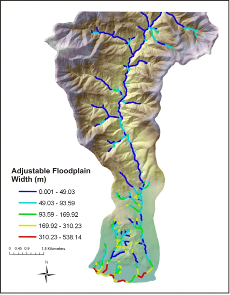
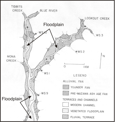
Figure 10. An example of variable floodplain widths and the diminution of floodplains in upstream parts of a mountain stream network (From Swanson, F.J., and James, M.E., 1975, Geology and geomorphology of the H.J. Andrews Experimental Forest, Western Cascades, Oregon: Pacific Northwest Experiment Station, USDA Forest Service ReseFieldh Paper PNW-188, 14 p.)
Figure 11. The alternating pattern of constrained valleys (canyons) and unconstrained segments (floodplains) are important in controlling the types, abundance, and spatial distribution of aquatic and riparian habitats within watersheds. Unconstrained floodplain segments generally offer higher quality and more diverse habitats compared to canyons. Discontinuous pattern of floodplain segments in rivers have been referred to as a “string of pearls” (Ward et al. 2002). Figure adapted from Ward et al. 2002.
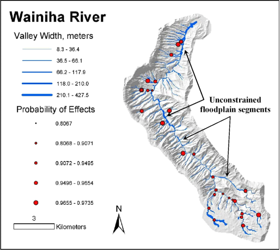
Figure 12. NetMap is used to predict floodplain widths across entire drainage basins and hence the amounts and locations of canyon and floodplain segments. These maps, in addition to predictions of geomorphically significant confluences, are used to identify areas of the potentially best habitats (biological hotspots). Because of the resolution of 10-m digital elevation data, the relative variation in floodplain and valley widths is more accurate than the absolute measures.