NetMap is used to conduct different types of risk analyses that involve identifying the spatial juxtapositions between predicted hazards (erosion, flooding potential, wildfire risk etc.) and sensitive and valuable aquatic resources. One NetMap tool that analysts can use to search for the highest to lowest values of any particular attribute (but not rasters) is called "Priority Search".
Priority Search
Model Description:
NetMap calculates the full cumulative distribution of any attribute in the Virtual Watershed datasets and thus a user can quickly search for and locate any specified portion of the distribution, such as the highest 1%, highest 5%, or highest 10% etc.
Tool Interface
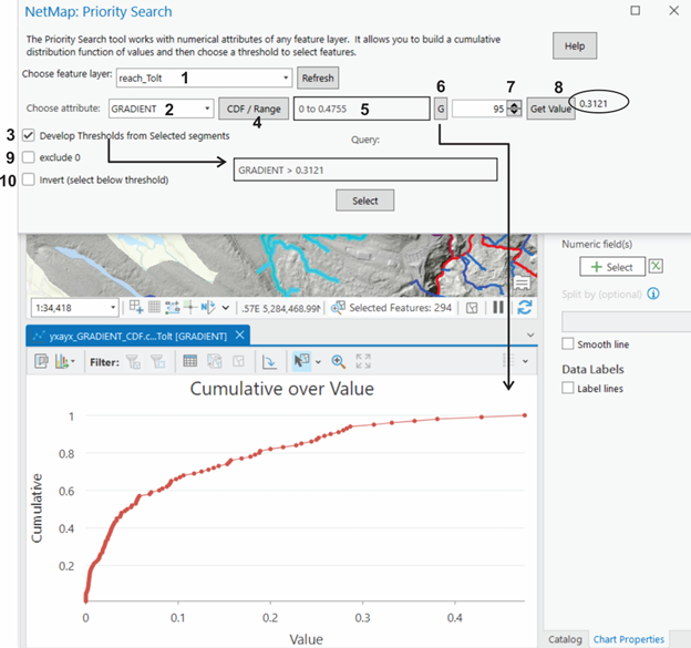
Figure 1. The Priority Search interface. A user selects a feature layer from the drop down list (1), showing all non raster layers in ArcMap's table of contents. If new layers are added, use the "refresh" button to have them show up in the list.A user then selects an attribute from the drop down (2). If attribute values include zeros, you can exclude those since they will affect the priority search (9). One can get the range of values for the attribute (4), which will show up in (5). (6) Allows you to plot the CDF which will be located in the table of contents. (7) User selects threshold value (when search for all the reaches above that value). The selected value is shown in (8). (6) Only a reach selection can be used to build the CDF and select the threshold, rather than the full dataset. Thresholds can be selected from a selection of reaches (3). The query is shown in the box. Use the select button to identify the segments. A user can invert (10) the selection (selecting below the threshold).