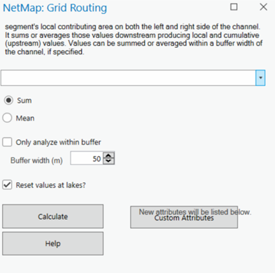
Parameter Description:This tool calculates the sum of all pixel values within each stream segment's local contributing area on both the left and right side ofthe channel, but circumscribed by a specified buffer. It sums those values producing local and cumulative (upstream) total values.
Data Type:Line (stream layer)
Field Name: selected raster name; Common Name: Provided by the user
Units: variable
Tool Interface: Select raster values to be routed from the drop down list. Select "sum" or "mean" values to calcuate. Specify the width of the buffer. Buffer width corresponds to one side of the channel, although the buffer encompasses both sides of the stream, same width. Routed values can be reset to zero at lakes, if routing an attribute that will be interupted by lakes, such as sediment.