TODO: To change the footer's content go to Dr.Explain menu Options : Project Settings : HTML (CHM) Export : Setup HTML Template and Layout
Floodplain Classes
Floodplains are often described in terms of the flood magnitude required to inundate them, such as the 2-year floodplain (overtopped by a flood that occurs, on average, once every two years) or the 10-year or 100-year floodplain.
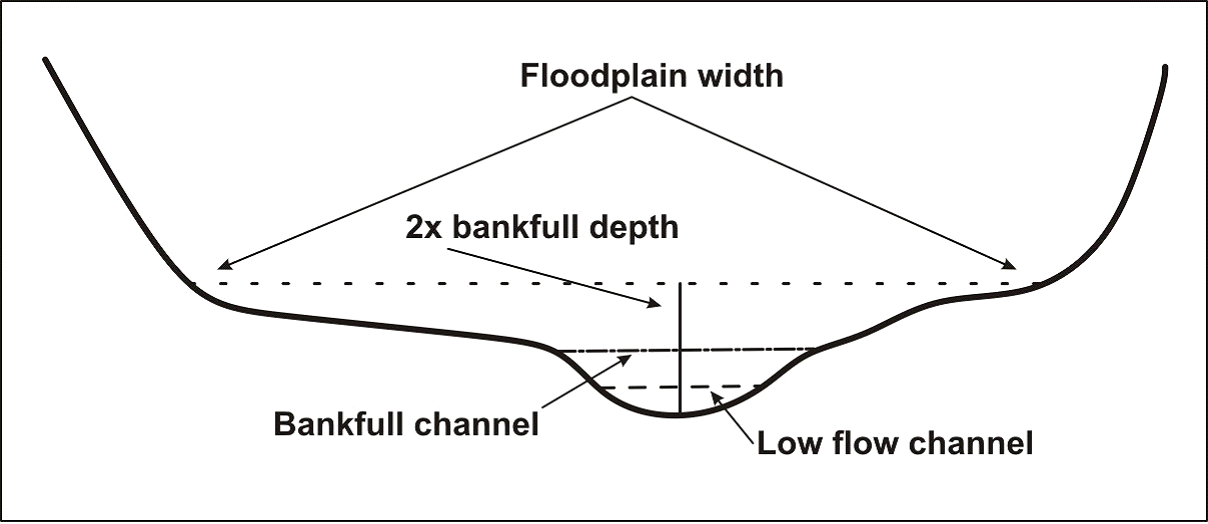
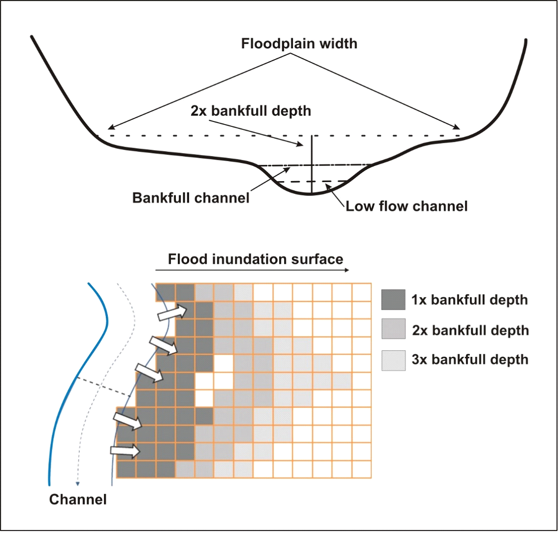
Floodplains in NetMap are mapped over a range of elevation bands above the channel, in terms of multiples of bankfull depths. Geomorphologists commonly define floodplain elevations in terms of bankfull depths so as to scale the mapped floodplain to the channel size. So, a floodplain at 2 times bankfull depth (2x) should represent the lowest floodplain, a surface that might get inundated every year or every few years. A floodplain at 3x should be flooded less frequently and so on. In NetMap-Portal, we provide floodplain polygons at 2x, 3x and 4x. A 4x floodplain polygon might be a terrace that rarely gets flooded.
Bankfull depths in channels are predicted using USGS regression equations that related channel bankfull depth to drainage area and sometimes precipitation, attributes also available in the "Streams & Habitats" domain of NetMap Portal.
Note that NetMap - Portal's floodplains extend across all streams and hence are much more extensive than FEMA floodplain mapping that is focused around urban areas.
Also see NetMap Portal's more detailed floodplain and valley floor mapping. If these attributes are not available for your own watershed, please contact us. See more.
Figure 10. NetMap’s floodplain mapping tool in WIP is used to identify the likely flood prone portions of the valley floor.
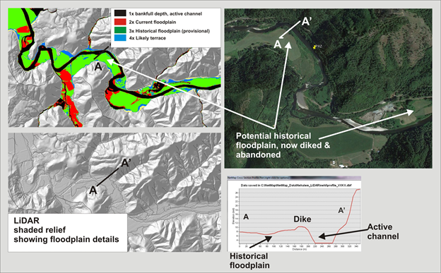
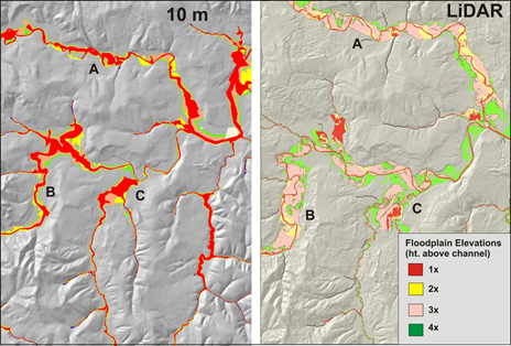
Floodplain at one multiple of bankfull depth (1x) generally identifies the active channel. Floodplain at two multiple of bankfull depth (2x) generally maps the lowest, most active floodplain, commonly thought to be inundated by the two-year flood (Dunne and Leopold 1978, Rosgen 1996). 3x floodplain is likely inundated by low frequency, high magnitude floods. 4x floodplain may represent an alluvial terrace or toeslopes of hillsides. Ditto for 5x and beyond.
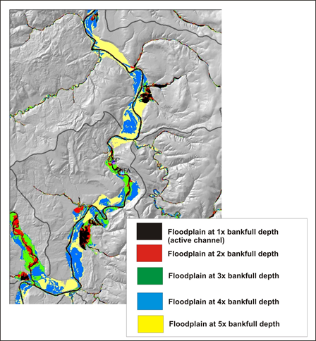
NetMap's floodplain mapping tool, particularly using high resolution LiDAR DEMs, can be used to identify the current floodplain and historical floodplains, now abandoned due to diking, stream cleaning, agriculture and channel incision; analysis in this figure uses 2.5 m LiDAR in the Nehalem watershed in northwestern coastal Oregon.
Although mapping floodplains using 10m DEMs (NetMap virtual watershed) is adequate (left panel), LiDAR (1-2m) provides considerably more detail and variability in floodplains.


 Floodplain at one multiple of bankfull depth (1x) generally identifies the active channel. Floodplain at two multiple of bankfull depth (2x) generally maps the lowest, most active floodplain, commonly thought to be inundated by the two-year flood (Dunne and Leopold 1978, Rosgen 1996). 3x floodplain is likely inundated by low frequency, high magnitude floods. 4x floodplain may represent an alluvial terrace or toeslopes of hillsides. Ditto for 5x and beyond.