New Drains, Slope Stability
Placement of New Drains and Slope Stability
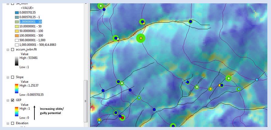
Using NetMap, placement of new drains must consider the potential for the new drain to trigger new gullies, landslides and debris flows. Two approaches are recommended. (1) The scientific literature identifies the use of the slope-area product, with area being the road surface segment area and the slope the hillslope gradient measured below the drain point (Montgomery 1994; Croke and Mockler 2001; Rakken et al. 2008). Thus, NetMap's road tool includes an attribute "slope area"; the higher the values the greater the potential that new drain runoff can trigger a gully or landslide. It is recommended that the attribute of reduced sediment of new drains by overlaid on top of the slope area attribute using a scheme shown in the figure below. To view these attributes, you may need to go to the complete NetMap virtual watershed dataset. See Warnings about using NetMap's slope stability tools.
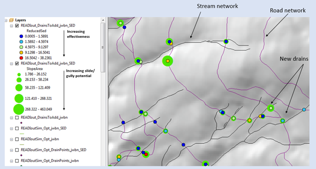 READI reduced sediment for new optimized drains overlaid onto predicted slope area product indicating the relative likelihood of new drain runoff to trigger gullies or landslides.
When considering placement of new drains, NetMap Generic Erosion Potential attribute should also be used, in conjunction with new drain attributes and the slope area product. See figure below. See Warning below.
To Users of NetMap's Erosion Prediction Tools
Applying shallow landslide, gully, surface erosion and debris flow models and predictions requires careful consideration of other factors including the applicability of any models to diverse landscapes (e.g., is model appropriate), other important factors such as climate, vegetation characteristics, soils, land-use activities, wildfire history, and landslide history (at any particular site and in the larger landscape). Model users should have expertise in geotechnical disciplines in order to appropriately interpret landslide and debris flow hazards.
Using models to predict erosion is never a substitute for field work and analysis. Models only provide an approximation of on the ground conditions. It is recommended to use both modeling, to provide a coarse level screening of erosion potential, followed up by field verification of model parameters (such as slope) and actual erosion conditions.
The boundaries between erosion potential map elements predicted by NetMap/TerrainWorks software (e.g., Virtual Watersheds and analysis tools) are approximate. Actual boundaries between mapping elements in any specific location need to be determined in the field, on site. In addition, not all small-scale landslide-prone features will be mapped and other features may be encountered during field inspections. Moreover, the sediment delivery potential (to streams and to other identified locations) of predicted erosion features, as well as any other erosion-prone landforms, should be verified in the field, on site.
The erosion predictions in the TerrainWorks/NetMap software are based on scientific information. However, any erosion prediction will contain inaccuracies and limitations because of 1) the relatively short and unique history of storms that triggered erosion and that are used to create the science (e.g., longer and different time periods and larger storms may yield different scientific results, models and understanding) and 2) the incomplete scientific understanding of all erosion mechanisms. For these reasons, all erosion predictions made by the TerrainWorks/NetMap software will not completely identify all of the potentially erodable areas. Regardless of the types of predictions made by the TerrainWorks/NetMap software, and including any and all applications by anyone, no warranties, express or implied, are made and in fact are disclaimed.
Anyone using NetMap (TerrainWorks) erosion tools need to have read and accepted the licensing agreement.