TODO: To change the footer's content go to Dr.Explain menu Options : Project Settings : HTML (CHM) Export : Setup HTML Template and Layout
Optimized New Drains
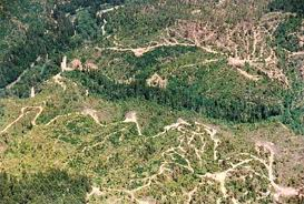
Unpaved roads can be the dominant source of land-use related sediment pollution in forested landscapes in the U.S. with impacts to water quality and aquatic biota. NetMap Portal contains a series of analyses that help identify which road segments are most likely to create sediment pollution and deliver it to the channel network. The new Road Erosion and Sediment Delivery Index model is used in NetMap; for additional information, go here.
If these attributes are not available for your own watershed, please contact us.
Using information on road-stream crossings and natural drainage points (e.g., low spots along roads), and in certain applications, GPS points for all engineered drains, and information on road surfacing types (paved, gravel, native soil), READI is used to predict sediment production on the road and more importantly sediment delivery. NetMap uses a dimensionless index for erosion and sediment delivery rather than units of mass per time (tons per year) given the great uncertainty in predicting erosion. The aim is to identify those road segments with the greatest potential to deliver sediment to streams, for prioritizing road maintenance and improvements. For additional information, go here.
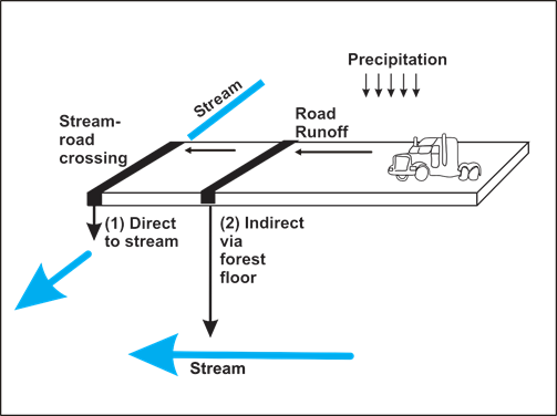
Figure 1. READI conceptual framework is based on a design storm with an assigned duration and intensity that produces road runoff (carrying sediment) that either is delivered directly to a stream at a road-stream intersection or indirectly to a stream via the forest floor at a natural or engineered drain location.
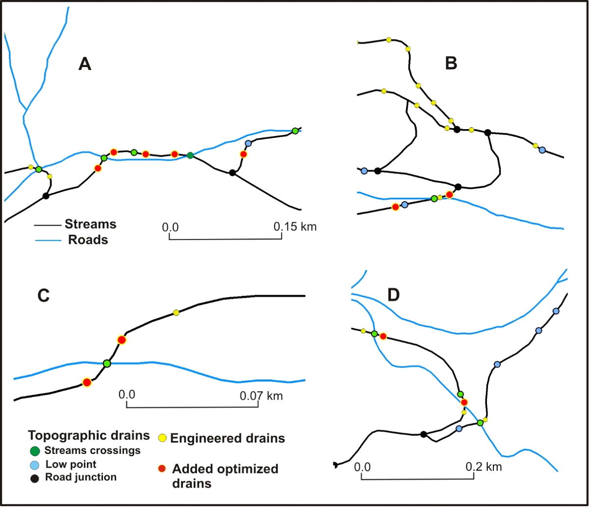
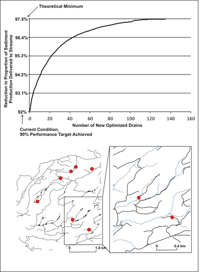
Figure 2. Examples of optimized drain locations. Other types of drains are shown including: a) stream crossings, b) natural low points along roads, and c) engineered drains (if available during the analysis, varies by client). Road segments are broken at road junctions.
Figure 3. (left) Predicted locations and effectiveness of optimized drains are ranked in terms of their effectiveness at reducing sediment delivery to stream. This prediction can be used to prioritize additions of new drains during various projects, including timber harvest and general road restoration. (Right) New optimized drains are ranked by effectivess at reducing sediment delivery. Effectiveness rapidly drops off with addition of more drains.
Placement of New Drains and Slope Stability
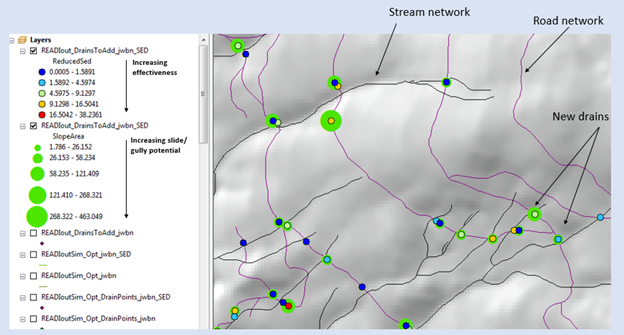
Using NetMap, placement of new drains must consider the potential for the new drain to trigger new gullies, landslides and debris flows. Two approaches are recommended. (1) The scientific literature identifies the use of the slope-area product, with area being the road surface segment area and the slope the hillslope gradient measured below the drain point (Montgomery 1994; Croke and Mockler 2001; Rakken et al. 2008). Thus, READI includes an attribute "slope area"; the higher the values the greater the potential that new drain runoff can trigger a gully or landslide. It is recommended that the attribute of reduced sediment of new drains by overlaid on top of the slope area attribute using a scheme shown in the figure below. To view these attributes, you may need to go to the complete NetMap virtual watershed dataset.
READI reduced sediment for new optimized drains overlaid onto predicted slope area product indicating the relative likelihood of new drain runoff to trigger gullies or landslides.
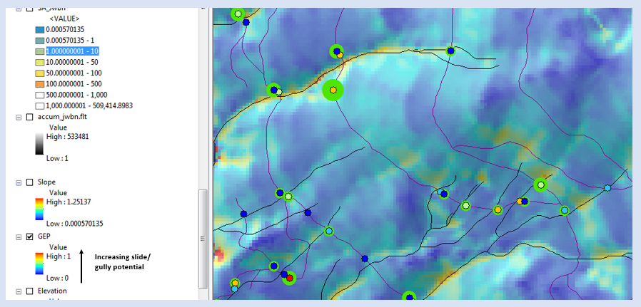
When considering placement of new drains, NetMap Generic Erosion Potential attribute should also be used, in conjunction with READI new drain attributes and the slope area product. See figure below.