| < Previous page | Next page > |
6.7 Road-Stream CrossingsRoad - Stream Crossings
Parameter Description: Roads that cross streams are classified according to the channel property of interest, including fish habitats (e.g., coho, steelhead intrinsic potential, etc.) and debris flow risk, etc. The resulting map identifies the stream segments that are crossed by the road, in color codes that reflect the selected parameter.
Data Type: line (reach)
Field Name: variable, depends on selected parameter; Common name: variable
Units: variable depending on selected parameter
NetMap Module/Tool: Roads
Model Description:
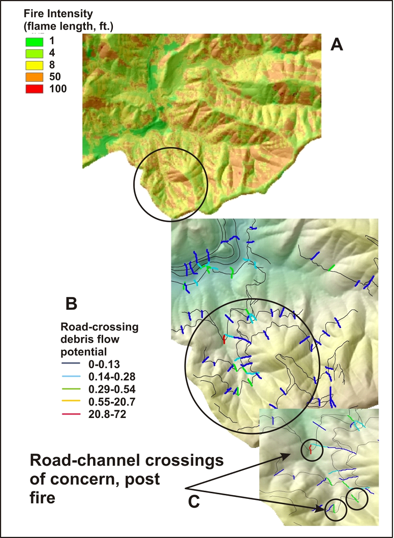
The tool identifies all road – stream crossings and then classifies the stream reach that is intersected by the road with the selected attribute (such as fish habitat, e.g., coho intrinsic potential or debris flow potential) (Figures 1 and 2). The tool may be used to identify road crossings that are susceptible to triggering debris flows and those roads that could be damaged by debris flows. Identifying road-debris flow potential intersections can also be applied in the context of pre and post wildfire risk management (Figure 3); and see Pre Wildfire Risk Management and Post Wildfire Risk Management in NetMap.
 Figure 1. NetMap’s road-channel classification tool allows users to identify road intersections with streams using various channel attributes. Show here is road overlaps with steelhead habitat quality (intrinsic potential).
 Figure 2. NetMap’s road-channel classification tool allows users to identify road intersections with streams using various channel attributes. Show here is road overlaps with debris flow potential.
 Figure 3. In NetMap, road segments (pixel scale) that cross channels are classified according to the debris flow potential. Overlaps between fire severity (A) and road segment-debris flow potential (B) can be used to identify road segments (pre or post fire) of potential concern (C) and thus were road maintenance or restoration could be targeted (either pre or post fire).
|