| < Previous page | Next page > |
Sort and RankSORT AND RANK TOOL
NetMap Module/Tool: Analysis Tools/Sub-basin Classification
Data Types: Polygons
Field Name:
Basin_
Units: Variable, depends on watershed attribute. Also, the classification will depend on the spatial scale of the analysis; using HUC 6 subbasins this might vary from HUC 5 to landscapes and entire states.
NetMap Level 1 Module/Tool: Analysis Tools/Sub-basin Classification
Use:
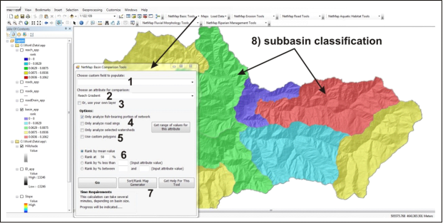
NetMap’s Sort and Rank tool is used to classify subbasins (typically US hydrologic unit code 6th field, 12 digit) in a NetMap Digital Hydroscape using available reach, grid or road data. NetMap calculates the cumulative distribution of any selected parameter within a population of subbasins (all subbasins within a watershed or only a subset of them). Any aspect of the distribution can be chosen to classify the subbasins (Figure 1). Thus, the Sort and Rank tool is used for conducting comparative analysis of one basin to another.
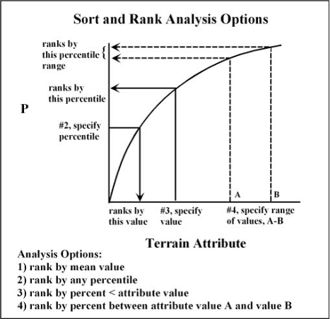
The tool creates cumulative distributions of the selected terrain parameter on the fly for each subbasin, and the user selects which aspect of the distribution to sort and rank by, including: 1) mean value, 2) an attribute value associated with any percentile of the distribution, 3) by percentile associated with less than any given attribute value, and 4) the percentile range associated with any range of attribute values (Figure 2). It is recommended that a user study an attribute map (and its range and distribution of values), including using Arc’s legend editor, to examine the histogram of values, thus to aid in conducting sort and rank exercises.
 Figure 1. NetMap’s Sort and Rank tool creates cumulative distributions (CDFs) for all individual subbasins within a set of polygons (shown here is HUC 6th field basins), thereby allowing a sorting and ranking of polygons by a number of statistical measures (Figure 2). (1) A user selects from a list of file names to store common sort and rank attributes (see Figure 4). (2) Or a user selects from a drop down list of NetMap attributes (Figure 3). (3) A custom layer (with a selected attribute) can be used. (4) Only a subset of attributes can be selected (e.g., limited to fish bearing network, road crossings or only selected watersheds). (6) An attribute of the distribution is selected for classifying (e.g., mean, and see Figure 2). (7) Previously saved sort and rank analyses (e.g., #1, Figure 4) can be selected and displayed. (8) The result is a classification of subbasin, in this case, by stream gradient.
 Figure 2. Netmap’s Sort and Rank tool creates cumulative distributions for each pre-defined polygon (such as HUC 6th or 7th field basins). The user must select what aspect of the distribution to search for (i.e., #6 in Figure 1). Options include: 1) means, 2) any percentile of the distribution, 3) by percent less than a given attribute value, and 4) by a percentage that lies between given attribute values.
 Figure 3. NetMap’s Sort and Rank tool contains a drop down list of all parameters (1) that can be used to classify subbasins (#2 in Figure 1).
 Figure 4. NetMap’s Sort and Rank tool contains a drop down list of commonly used attributes for later retrieval (#1 in Figure 1).
|