NetMap's Watershed Assessment
Watershed Attribute: The susceptibility of channels to debris flow movement, scour and deposition, in terms of probability; an empirical model (Miller and Burnett 2008); but specifically focusing on tributary confluence related impacts.
Refer to Debris Flow parameter for additional background information.
The model is most applicable to the Oregon Coast Range; however, it utilizes topographic information that has been found to be relevant to debris flow movement in other terrains (Swanson and Lienkaemper 1978, Hungr et al. 1984, Benda and Cundy 1990, Fannin and Rollerson 1993, Fannin and Wise 2001). In all landscapes, the debris flow predictions should be considered as a screening tool. Field measurements and on the ground surveys are needed to make more accurate predictions.
Data Types: Line (in channel) and confluence points.
Field Name: DF_Junct;
Units: Probability (0-1). The modeled relative spatial frequency of debris flow scour and deposition (and traversal, neither scour or deposition). For example, all reaches with the same modeled P_DF_AVE value have similar physical characteristics found empirically related to debris-flow occurrence (number of landslide sources, the length, steepness, and confinement of the potential debris-flow tracks leading from those landslide source areas to the reach). The P_DF_AVE value reflects the relative proportion of similar reaches mapped with debris-flow effects. We expect, therefore, out of 1000 reaches with a P_DF_AVE value of 0.02, we should find twice as many with evidence of debris-flow deposition or scour than in 1000 reaches with a P_DF_AVE value of 0.01. Hence, the model output provides a relative likelihood of debris flow potential in any stream reach, relative to all other similar stream reaches in a landscape. Although the model is calibrated using a population of stream segments following a major (1996) landslide triggering storm in the Oregon Coast Range, it is assumed that the relative likelihood of debris flows found in that case can be applied to other landscapes where debris flows are driven by similar topographic and climatic controls.
NetMap Level 1 Module/Tool: Mass Wasting/Slope Stability
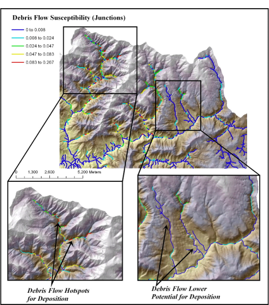
Figure 1. “Debris flow susceptibility-junctions” is predicted for tributary confluences in a portion of the Wilson River basin (Oregon Coast Range). This type of prediction will facilitate comparison of debris flow susceptibility with other channel and habitat parameters in NetMap Watershed Assessment, Level 1.