NetMap's Watershed Assessment
Data Type: Stream layer, road layer
Field Name: RddWEPP_Rd; roadWEPP sediment production (road shapefile)
Field Name: RddWEPP_Yd; roadWEPP sediment delivered to streams (road shapefile)
Field Name: RdWEPP_Yld; roadWEPP sediment - in reaches (reach shapefile)
Field Name: RdWEPP_Cum; roadWEPP sediment - in reaches - summed (reach shapefile)
Field Name: RdWEPPSum; roadWEPP sediment production-summed (orig roads) (original road layer)
Field Name: RdWEPPDSum; roadWEPP sediment delivery-summed (orig roads) (original road layer)
Field Name: RdWEPPPav; roadWEPP sediment production-per meter (orig roads) (original road layer)
Field Name: RdWEPPDav; roadWEPP sediment deliver-per meter (orig roads) (original road layer)
Units: tons/yr
NetMap Module/Tool: Erosion Processes/Road Surface Erosion
Model Description:
The WEPP road surface erosion model is used within NetMap; refer to (http://forest.moscowfsl.wsu.edu/fswepp/) for additional information. The road network (lines) is first broken at pixel cell boundaries (Figure 1). The individual, approximately pixel scale road cells, are then re-aggregated into hydrologically connected segments (tens to a hundreds of meters in length) that represent water flow paths from high (topographic) points to low (pour) points or to defined streams. These hydrological road segments can be viewed in terms of their drainage diversion potential. For example, in the absence of secondary road drainage structures, the drainage diversion road segments should indicate the water diversion potential of any road segment, particularly under conditions such as during large storms or following wildfires. Refer to NetMap’s Road Drainage Diversion Potential parameter.
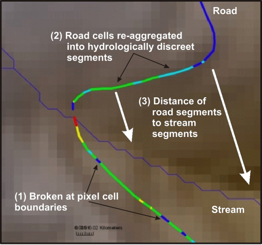
Figure 1. In NetMap, road layers (lines) that may be kilometers long are broken at pixel cell boundaries (1). They are then re-aggregated into hydrologically discreet segments between topographic high and low (pour) points using NetMap's road drainage tool. These segments are used in the WEPP road surface erosion model. In addition, each road segment is linked (by distance and hillslope gradient) to the nearest downslope channel segment, called the “buffer” in WEPP, that influences the potential for road sediment to enter streams.
Surface erosion on roads is governed by road gradient, length of road that is hydrologically connected (e.g., length of overland flow on a road surface), road width, road surfacing (native, gravel), traffic level (high to low), and time since grading (Luce and Black 1999, Sugden and Woods 2007). The WEPP road surface erosion model (Elliot et al. 1995, http://forest.moscowfsl.wsu.edu/fswepp/docs/wepproaddoc.html) employs the parameters of road width, drainage length, road gradient, surface material, soil type and traffic level. Since WEPP predicts sediment delivery to streams (t/yr), the intervening hillslope distance (and gradient) between individual road segments and the nearest stream influences the amount of sediment delivered to channels. If the road drains directly to a stream channel, no buffer is considered.
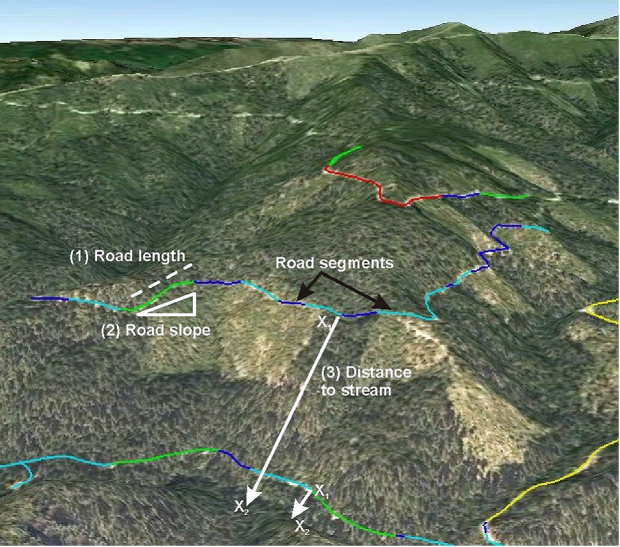
Figure 2. Important factors of road surface erosion include road segment length (1) that is hydrologically distinct (shown by the different color codes, the slope of the road (2), and the distance of individual road segments (drain or pour points) from individual stream segments (3).
The objective of the NetMap analysis of road surface erosion is to identify road segments that have a high likelihood of producing large amounts of fine sediment and delivering that sediment to high value streams and fish habitat. Road surface erosion can be reduced by increasing the number or frequency of cross drains (thereby reducing the effective length of overland flow on a road surface) and improving road surface materials (such as placement of gravel on a native soil surface). Reducing road surface erosion can be reduced by placement of rolling dips and other secondary drainage structures such as ‘open tops” (Figure 3). Continuing road maintenance can be expensive and in recent years resource managers have seen budgets severely limit their capacity for that work. In some cases managers are abandoning, storing, or decommissioning roads in efforts to remove their long-term impacts in critically important areas. Because road restoration, including obliteration and recontouring, also can be very expensive (though it does limit long term maintenance) it is increasingly important to be able to focus limited restoration funds where they can be most useful.
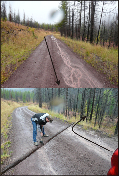
Figure 3. (Top) Long stretches of road can be hydrologically connected, via overland flow. In the Clearwater River basin that can lead to considerable surface erosion and the delivery of both fine sediments and other materials (nutrients) to streams. (Bottom) The use of cross drains (a form called ‘open tops’ in the photo) can be used to decrease the length of overland flow and thus decrease the amount of surface erosion and the volume of sediment and other materials reaching stream channels. Arrows illustrate the accumulation of flow and its disruption due to the cross drain, during conditions of light rain
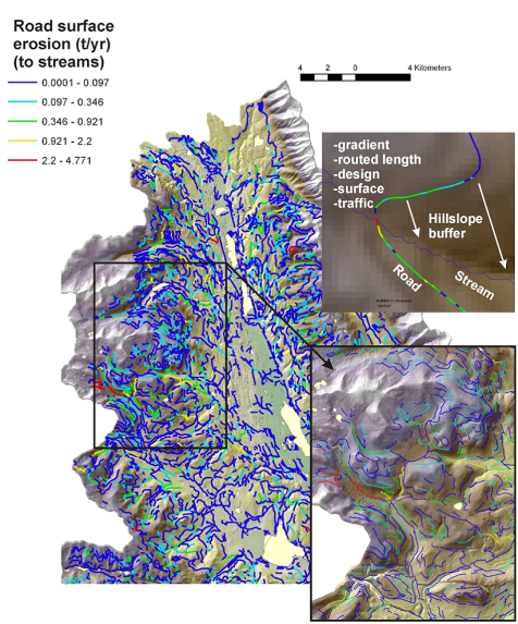
Figure 4. Road surface erosion (as delivered to streams) in the Clearwater basin ranged from very low (near zero) to a maximum of 4.7 tons/year. In the figure, individual road segments are color coded according to predicted annual sediment yield. Predicted sediment yields to streams are sensitive to the hillslope distance and gradient (e.g., buffer) from individual road segments to streams, as illustrated in the figure (upper right).
