NetMap's Watershed Assessment
Watershed Attribute: Shallow Landslide Potential (equivalent to gully erosion potential in some landscapes, see Figure 1). The susceptibility of hillslopes to shallow failure and to gullying based on a topographic index combining slope steepness with slope convergence. Slope steepness is a fundamental control on erosion potential. Convergence causes surface and subsurface flow to become concentrated and therefore contributes to erosion potential.
Although NetMap tools (Level 2) can adjust the sediment delivery criteria of shallow landslide potential, the Level 1 attribute assumes delivery to all channel segments (of any slope gradient including steep headwaters). To adjust sediment delivery criteria, NetMap tools are required. In addition, users can calibrate the shallow landslide (and debris flow, see later) model to their local landslide data, thus making the model more accurate for specific landscapes and watersheds; this is a Level 2 Tool.
Data Types: Grid (raster) and line (in channel). There are six data layers (two rasters and four lines). See also Watershed Assessment data types and uses.
Grids (rasters)
Field Name: GEP_GRID;
Field Name: GEP_DEL_GRID; (the delivered to streams version of GEP_GRID).
Line (in-channel) data for total and delivered to streams shallow landslide potential
Field Name: GEP; GEP per channel reach
Field Name: GEP_CUM; GEP aggregated (or routed) downstream
Field Name: GEP_DEL; GEP_DEL per channel reach
Field Name: GEP_DEL_CUM; GEP_Del aggregated (or routed) downstream
Units: Numerical values, range from 0 to >1
NetMap Level 1 Module/Tool: Mass Wasting/Slope Stability
Generic Erosion Potential (GEP), based on slope steepness and convergence, represents the potential for at least three different types of erosion and hazards (see Figure 1 below).
Figure 1. The shallow landslide index (GEP) can apply to two to three types of erosion processes (and risks) depending on the climate zone (humid, semi-arid, arid).
Model Description: (delivery to channels not considered)
NetMap’s generic erosion potential (GEP) provides a relative measure of potential erosion and it focuses on slope steepness and convergence, recognized topographic indicators of shallow landsliding, gully erosion, and sheetwash (Montgomery and Dietrich 1995, Miller and Burnett 2007, Parker et al. 2010). It is based on topographic attributes of slope gradient, local contributing area, and topographic convergence derived from the DEM:
GEP = S*aL/b
where S is slope gradient (m/m), aL is a measure of local contributing area to a DEM pixel equal to the number of adjacent pixels that drain into it (varies between 0 and 8), and b is a measure of topographic convergence equal to the projection of flow direction out of a pixel onto the pixel edges. Values of b are 1 on planar slopes, less than 1 on convergent topography, and greater than 1 on divergent topography. Larger values of GEP correspond to steeper, more convergent topography. Higher values of GEP correspond to higher landslide densities and, in areas prone to surface erosion, to higher gully-initiation-point densities (Miller and Burnett 2007); note that this parameter does NOT apply to deep seated landslides and earthflows (excetp for certain parts of their topography) (Figure 3). NetMap’s GEP index provides a relative measure of erosion potential (e.g., high – low) that encompasses processes of shallow landsliding, gullying, and surface erosion and which can be used in both humid and semi arid landscapes (Figures 2 and 4).
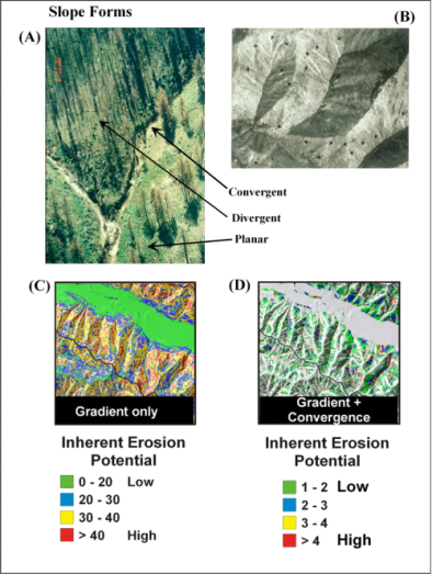
Figure 2. Steep, convergent areas in many landscapes are prone to various forms of erosion including (A) gullying in semi-arid areas, particularly following fires and (B) shallow failures in humid landscapes. Hillslopes can be categorized into (A) convergent, divergent, and planar forms. Slope gradient alone (C) can be used as an approximate indicator of erosion potential since all forms of erosion are strongly governed by slope. A more accurate predictor of erosion potential is slope combined with a measure of topographic convergence to create an intrinsic index of erosion potential (D). NetMap’s GEP index that uses both slope and convergence provides a useful screening of erosion potential across large areas (Figure 2).
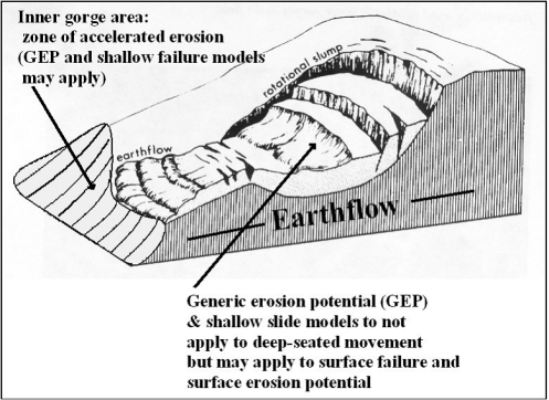
Deep Seated Landslides and Earthflows
Figure 3. Generic erosion potential and shallow landslide models apply to erosion potential (mass wasting and post-fire surface erosion) that is driven by hillslope gradient and convergence. GEP-type models may also apply to areas not captured by topographic expression on 10-m DEMs such as inner gorges near streams. GEP-type models do not apply to deeper movement in earthflows and rotational slumps but may apply to surface erosion processes on the slope of deep-seated features
Delivery or Connectivity Potential
To calculate the potential for sediment delivery (for landscapes where hillslope steepness and convergence promote erosion, including shallow failure), the model traces the down slope flow path until it intersects a stream. The calculated probability for sediment to be transferred to each downslope cell decreases monotonically as a function of gradient and topographic confinement (based on field data from the Oregon Coast Range, see Miller and Burnett 2007a). [note: sediment delivery applies to mass wasting sediment delivery, say by debris flow or landslide. It also does not apply to surface erosion processes.] The probability that sediment will reach a stream is assigned to the source cell. This is repeated for all hillslope pixels. The resulting raster file provides a map of potential for sediment delivery (to a stream) for every pixel cell in a basin. The probability of sediment delivery is then multiplied to the GEP value, thus providing a prediction of sediment delivery from GEP ranked hillslopes (Figure 4).
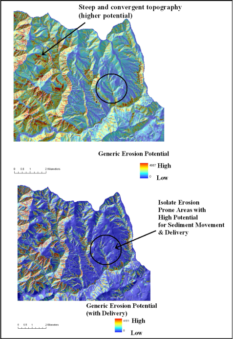
Figure 4. (Top) The NetMap parameter of shallow landslide potential identifies steep and convergent areas providing a relativistic ranking of erosion potential targeting shallow landslides, and surface erosion and gullying. (Bottom) GEP is adjusted according to its potential for sediment delivery to streams; this applies only to mass wasting processes and it does not apply to surface erosion sediment delivery.