NetMap's Watershed Assessment
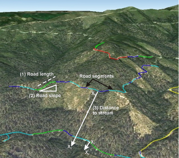
Watershed Attribute: The susceptibility of roads to surface erosion and the delivery of sediment to stream channels are predicted using a simple relationship between predicted road hydrologic connectivity (e.g., length between drain points, either at streams or on land), road slope gradient, and the distance of the road segment to the stream.
Data Type: Road layer
Field Name: INDEX; Road erosion index
Field Name: slope; Road slope
Field Name: length; Road length
Units: #/m, L/L, m
NetMap Module/Tool: Road Module/Road Surface Erosion
Model Description: Road surface erosion index - LR * LS/(LH2)
where LR equals the predicted road hydrological connectivity, LS equals the slope gradient of the road, and LH is the hillslope length between the road and the stream to which the road drains to. The non linear dependency of sediment delivery to streams from road erosion based on hillslope length (the distance of the road to the stream channel, e.g., LH2) is based on empirical findings that sediment delivery potential decreases non linearly with distance of the road to the stream.
Figure 1. Important factors of road surface erosion include road segment length (1) that is hydrologically distinct (shown by the different color codes), the slope of the road (2), and the distance of individual road segments (drain or pour points) from individual stream segments (3). A simple index or proxy of road surface erosion uses those three parameters. Road segment length that is hydrologically connected is predicted by another watershed attribute in the Watershed Assessment Package - Roads.