NetMap's Watershed Assessment
Watershed Attribute: Road drainage diversion or road hydrologic connectivity. Predicted using digital elevation models and GPS drain point locations where available. Used alone or in conjunctoin with road surface erosion predictions.
Data Type: Line (road layer)
Layer name: roadGRAIP (for use with GRAIP-Lite)
Layer Name: roadDrain (worst case, road drainage diversion)
Units: road length (m) and road gradient (L/L); distance of individual road segments to individual stream segments are included.
NetMap Module/Tool: Roads
Model Description:
Road layers are comprised of line work with road segment lengths of typically multiple kilometers. To facilitate calculation of road drainage diversion potential and road surface erosion potential, the road segments are broken into smaller segments that reflect road drainage into streams and road drainage off of roads at other locations (e.g., road drain points) (Figure 1). The road drainage tool is used to create three different road layers (depending on whether road surface erosion is calculated); for GRAIP-Lite tool (creating the ‘roadGRAIP’ road layer); for WEPP road surface erosion tool (creating the ‘roadWEPP’ road layer); and one to calculate road drainage diversion potential (creating the ‘roadDRAIN’ road layer).
The road drainage segment lengths that are calculated should reflect the actual road drainage conditions in the field. For example, the average road drain spacing (culverts, rolling dips etc.) may be 50 m. Calculations can accept estimates for maximum drainage spacing (geo referenced drainage points are preferred).
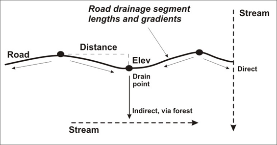
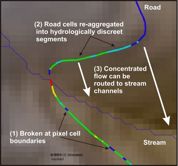
Figure 1. NetMap’s road drainage tool divides long road segments into shorter ones that reflect topographic low and high points along the road that would create drain points and flow into stream channels. The change in elevation (between high and low points) and the distance over which that is calculated are used to determine the range and average road segment spacing (Table 1) and correspondingly the road segment gradient. Road segment length and gradient are required to estimate road surface erosion potential using GRAIP-Lite and WEPP roads (if these calculations are desired). Note also that a user may import their own GPS locations of road drainage structures (as a point shape file). Road segments will be broken at those locations but also other breaks in the road network according to topography will still be included.
Table 1. A sensitivity analysis that shows how changing elevation and distance will affect the average and maximum length of road segments for use in GRAIP, WEPP and drainage diversion potential. These values do not include user supplied GPS road drainage points.
|
Elevation Change (m)
|
Distance (m)
|
Average Segment (m)
|
Minimum Segment (m)
|
Maximum segment (m)
|
|
0.01
|
300
|
47
|
0.017
|
1276
|
|
0.1
|
300
|
60
|
0.017
|
1276
|
|
0.5
|
300
|
80
|
0.017
|
1727
|
|
1
|
300
|
95
|
0.003
|
1727
|
|
3
|
300
|
140
|
0.003
|
2366
|
|
5
|
300
|
165
|
0.003
|
3300
|
|
|
|
|
|
|
|
1
|
50
|
86
|
0.003
|
1727
|
|
1
|
100
|
94
|
0.003
|
1727
|
|
1
|
200
|
95
|
0.003
|
1727
|
|
1
|
300
|
95
|
0.003
|
1727
|
|
1
|
400
|
95
|
0.003
|
1727
|
|
1
|
500
|
95
|
0.003
|
1727
|
|
1
|
1000
|
95
|
0.003
|
1727
|
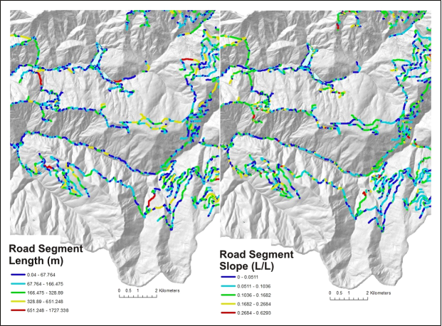
Figure 2. Example output from the road drainage tool showing road segment lengths (left) and corresponding road gradients (right). These two parameters are used to make road surface erosion predictions, in addition to other factors in the models.
Figure 3. In NetMap, road layers (lines) that may be kilometers long are broken at pixel cell boundaries (1). They are then re-aggregated into hydrologically discreet segments between topographic high and low (pour) points (2). These segments can be used to indicate the potential for road drainage diversion.
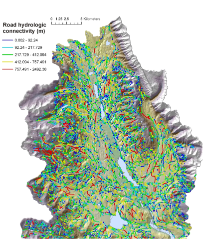
Figure 4. Predicted road hydrologic connectivity ranged between ten and 2500 meters (average 133 m) in the Clearwater Basin, Montana. This parameter could be viewed as an index of ‘road drainage diversion potential’ during large storms or following fires when secondary drainage structures may be compromised,. The drainage diversion index could be used to identify locations where field crews could check on drainage efficacy during or after storms or following fires.